This is a comprehensive guide for people who would like to climb Mount Ishizuchi, the tallest mountain in Western Japan. The guide covers the two main transportation routes to the trailheads from Matsuyama and JR Iyo-Saijo Station respectively. Both routes have a day-hiking, overnight camping, and ryokan lodging options. All Shikoku Pass or JR Pass users can consider taking the train to Iyo-Saijo to make this a day activity.
This guide also includes hiking route time estimates, some activities or highlights of notes, and lodging options.
Please note that this guide was migrated from an old blog and still needs some formatting updates. Please be patient (or help if you know how to use markdown). If you’re very frustrated, check out the Web Archive for my post on how I did the day hike. Thanks!
Information Overview of Mount Ishizuchi
This is a mega information dump post. The first section is information on all the possible transit time tables from different locations to Mount Ishizuchi. The second section covers my transit connections and lodging information – scroll down to “Mount Ishizuchi Ropeway and Lodgings”.
Mount Ishizuchi is the tallest mountain in Western Japan, with its peak Tengudake sitting at 1982 metres. The mountain is both a cultural landmark as a holy site for Shinto and Shugendo, as well as a popular hiking route for recreational and overnight hikers. The mountain has a signature sheer peak and is famous for its three sets of gigantic chains that climbers can use to get to the top (optional use). In the Fall, Mount Ishizuchi is famous for koyo, autumn foliage, where it attracts many visitors. In the Winter, it has a new years mountain festival, but I would not advise on hiking, as the mountain has snow and is a ski ground. Officially, the mountain hiking route is open between July and October, though you could probably hike it in late Spring and Fall as well.
Ishizuchi’s Hiking Season & Trail Recommendations
 The last of the 3 famous chains to reach Mount Ishizuchi’s peak.
However, visitors should note that the mountain is high enough to have snow, so you can consider that the mountain is “closed” for hiking in winter.
Mount Ishizuchi’s paths are well-kept and natural. This means that the routes are dirt paths that are kept clear of weeds and fallen leaves. As the paths are natural, heavy rains can create extremely muddy troughs.
I highly recommend giving yourself at least one overnight stay to enjoy the highland air and natural scenes. If you are adhering to the bus schedule, you will have to walk fairly quickly and there won’t be much time to sit and just take in the view. For trekkers coming from Matsuyama, you can either stay at Kuma Kogen where the bus transfer is, or on top of Mount Ishizuchi.
Other hiking routes around Mount Ishizuchi
Mount Ishizuchi is connected by a series of hiking trails that can go to other peaks such as Mount Iwaguro 岩畔, Mount Otoko 男山, Mount Kamegamori 瓶ヶ森山, Mount Daigamori 代ヶ森, Mount Komochi-gongen 子持権現山, and Mount Ibuki 伊吹山. There are some rest huts and cabins up in the mountains that are like shacks without any amenities. Please also refer to this to this Ishizuchi Map.
Transportation Overview
From JR Iyo-Saijo Station, day-hikers can take a bus and cable car up to the mountain to complete the Omotesando Route and catch public transportation back. Transportation to Ishizuchi from Matsuyama takes a bit longer to get to and requires hikers to climb the full height of the mountain.
Below is a general breakdown to help you figure out what route might be suitable for your trip itinerary and the transportation needed to get to Mount Ishizuchi’s trail heads.
| DAY HIKE | OVERNIGHT | |
|---|---|---|
| From Matsuyama | Bus to Ishizuchi Tsuchigoya | Bus to Omogo |
| From JR Iyo-Saijo | Bus to Ishizuchi Ropeway + Cable Car | Bus to Ishizuchi Ropeway only |
| From Yokomine-ji | Walk from Yokomine-ji |
The guide below is formatted by where you are coming from. In each of the main sections, you will find additional information on transit times, basic hiking route information, and notes on accommodation. Below are three main places travellers start from to get to Mount Ishizuchi:
- Matsuyama to Ishizuchi-Tsuchigoya
- Matsuyama to Omogo
- Matsuyama to Kuma Kogen (and day hikes in the area)
- JR Iyo Saijo Station to Ishizuchi Ropeway
- JR Iyo Saijo Station to the Omotesando Route
- Yokomine-ji, Temple #60 in the Shikoku Pilgrimage
From Matsuyama to Ishizuchi-Tsuchigoya (Direct)
The closest main city to Mount Ishizuchi is Matsuyama, which is the capital of Ehime Prefecture and also has an airport. There is public transportation directly to 2 trailheads for Mount Ishizuchi. The further trailhead (Omogo) runs year round, but the closer trailhead (Tsuchigoya) is only during the season when the mountain is open.
 The “Botchan Clock” at Dogo Onsen is a landmark in Matsuyama
Hikers going directly from JR Matsuyama Station will need to do a bus transfer at the town of Kuma Kogen. The first bus is takes you from JR Matsuyama Station to Kuma Kogen and is run by JR Shikoku Bus. The second bus is run by Iyotetsu Buses and takes you from the Kuma Kogen Business Office to Omogo. Note that buses to Ishizuchi-Tsuchigoya only operate on weekends and holidays.
Please refer to the bus service time tables below for the two daily bus routes to Tsuchigoya. For hikers who would like to hike from the further trailhead at Omogo, please proceed further down for additional bus times.
**Iyotetsu Nanyo Bus Summer Service Times: **
- Operates April 1 – November 30
- Saturdays, Sundays, and Holidays
- 2 buses a day only
- There are more daily buses to Omogo
Buses from Matsuyama JR Station to Ishizuchi-Tsuchigoya (via Kuma Kogen)
| JR Shikoku Bus | Iyotetsu Nanyo Bus(Summer) Weekends Only | |||
|---|---|---|---|---|
| JR Matsuyama Station | Kuma Kogen | Kuma Business Centre | Omogo | Ishizuchi Tsuchigoya |
| Departs | Departs | Departs | Departs | Arrives |
| 6:30 | 7:32 | 7:50 | 8:50 | 9:28 |
| 10:30 | 11:33 | 14:00 | 15:02 | 15:40 |
Buses Ishizuchi-Tsuchigoya (Via Kuma Kogen) to Matsuyama JR Station
| JR Shikoku Bus | Iyotetsu Nanyo Bus(Summer) Weekends Only | |||
|---|---|---|---|---|
| JR Matsuyama Station | Kuma Kogen | Kuma Business Centre | Omogo | Ishizuchi Tsuchigoya |
| Departs | Departs | Departs | Departs | Arrives |
| 6:30 | 7:32 | 7:50 | 8:50 | 9:28 |
| 10:30 | 11:33 | 14:00 | 15:02 | 15:40 |
Source: Ishizuchi Bus Information (Japanese PDF)
Note that this information is provided for simplicity. There are more regular buses to Kuma Kogen, and also to Omogo, which you can find in the sections below.
Hiking Route from Ishizuchi-Tsuchigoya to Mount Ishizuchi
 *Joju points back down to the cablecar, while Tsuchigoya points to the bus stop going to Kuma Kogen on weekends — Photo by Athena Lam Original: The Cup and the Road
*
*Joju points back down to the cablecar, while Tsuchigoya points to the bus stop going to Kuma Kogen on weekends — Photo by Athena Lam Original: The Cup and the Road
*
Time from Bus Stop (One-Way): 2.5 – 3 hours
The 2nd page of this English guide has a general route map for the route from the entrance of Mount Ishizuchi and the Tsuchigoya bus stop. It also has 2 hostel listings.
Note that bus service to this route is only available between April 1 and November 30. From the bus stop, there is a public toilet before you ascend the mountain. In addition, you can stop by Ishizuchi Shrine, with the sacred grounds marked by a red torii gate before your ascent. Note that there are 2 routes up the mountain.
Route 1 (approx 2.5 hours one-way): The most direct route, via Mount Tsuru-no-ko-no-Kashira 鶴の子の頭. Note that this route comes up behind the mountain, which means you will not be climbing the three famous chains.
Route 2 (approx 4.5 hours one-way): This route is multisectional, so look for the signs that point you to Mount Ishizuchi 石鎚山.
From Matsuyama to Omogo
Click here for Google Map Link
This is section is additional information for people who want to head into the highlands in general, or who may want to stay overnight for a day or two. JR Shikoku buses run daily between Matsuyama Station and Kuma Kogen town as public transportation. Below are some of the main stops between Matsuyama and Kuma Kogen town.
Below, I have compiled the public bus time schedules. However, I believe the transfer bus stop between the JR Shikoku Bus and the Iyotetsu Bus are not not the terminus stops. To ensure you get off at the right place, please say to, or show, the bus driver:
“Ishizuchi-yama ni ikmasu. Norikae no basu-tei ni tomattekudasai.”
石鎚山に行きます。乗換のバス停に止まってください。
Please note that some buses only run on weekdays and others only on weekends.
From Matsuyama JR Station to Omogo
| JR Shikoku Bus | Iyotetsu Nanyo Bus (Summer Service) | |||
|---|---|---|---|---|
| JR Matsuyama Station | Kuma Chugaku Mae | Kuma Kogen | Omogo | |
| Departs | Departs | Departs | Departs | |
| Sat/Sun/Hol | 6:30 | 7:32 | 7:50 | 8:50 |
| Weekdays | 6:30 | 7:32 | 9:30 | 10:30 |
| Weekdays | 8:30 | 9:36 | 11:00 | 12:00 |
| Sat/Sun/Hol | 10:30 | 11:33 | 14:00 | 15:02 |
| Weekdays | 10:30 | 11:33 | 14:35 | 15:35 |
| Weekdays | 15:50 | 16:58 | 17:50 | 18:50 |
From Omogo to Matsuyama JR Station
| Iyotetsu Nanyo Bus (Summer Service) | JR Shikoku Bus | |||
|---|---|---|---|---|
| Omogo | Kuma Kogen | Kuma Chugaku Mae | JR Matsuyama Station | |
| Departs | Departs | Departs | Arrives | |
| Weekdays | 6:55 | 7:55 | 8:01 | 9:06 |
| Weekdays | 8:30 | 9:30 | 10:11 | 11:15 |
| Sat/Sun/Hol | 12:10 | 13:04 | 15:11 | 16:19 |
| Weekdays | 12:30 | 13:30 | 15:11 | 16:19 |
| Sat/Sun/Hol | 17:05 | 18:00 | 18:41 | 19:49 |
| Weekdays | 17:10 | 18:04 | 18:41 | 19:49 |
Source: Iyotetsu Bus Timetable (Japanese PDF) and JR Shikoku Bus timetable for the Matsuyama – Kuma Kogen route (Japanese)
Hiking Route from Omogo to Mount Ishizuchi
 The Ishizuchi view towards the Omoge and Kuma Kogen direction.
Time from Kamebara Cliff (One-Way): 3 – 4 hours
If you get off at Omogo Stop, you will have to walk about 1 kilometre to various sight seeing spots, and about 3 kilometres to the trailhead 登山口.
When you get off, you will be walking along a stream and you can follow signs to the Maple Leaf Rock, also called the Momiji Rock. That area has a few famous sights, such as the Yoroi Rock, Nunobiki Waterfall, and the Kamebara Cliff. After you pass the camping sites, you will get to a final washroom at the trail head 登山口. There is only one main hiking route, but you can look for signs that say Mount Omogo 面河山 and Mount Ishizuchi 石鎚山. This part of the route takes about 2.5 hours one-way.
From Matsuyama to Kuma Kogen Only
Click here for the Google Map of the route.
Finally, for people who want to go to the highlands, here are the buses that go to the town of Kuma Kogen. I have also included some additional stops in the city of Matsuyama in case you would like to get on from other central areas.
Buses from Matsuyama to Kuma Kogen Town
Daily Daily Weekdays Daily Daily Daily Weekdays Only Sat, Sun, Holidays Weekdays 松山
Matsuyama 6:50 8:30 10:30 12:30 15:30 17:20 18:40 19:30 20:10 大手町 Otemachi 6:51 8:31 10:31 12:31 15:31 17:21 18:41 19:31 20:11 市役所前 City Hall 6:54 8:34 10:34 12:34 15:34 17:24 18:44 19:34 20:14 県庁前 Prefectural Hall 6:55 8:35 10:35 12:35 15:35 17:25 18:45 19:35 20:15 大街道 Okaido 6:58 8:38 10:38 12:38 15:38 17:28 18:48 19:38 20:18 33 Stops – – – – – – – – – 久万中学校前 Transfer to Omogo Bus 7:58 9:38 11:38 13:38 16:38 18:28 19:48 20:38 21:18 西本医院前 7:58 9:38 11:38 13:38 16:38 18:28 19:48 20:38 21:18 久万高原 8:00 9:40 11:40 13:40 16:40 18:30 19:50 20:40 21:20 Source: JR Bus Time Table for the Matsuyama – Kuma Kogen route (Japanese)
Buses from Kuma Kogen Town to Matsuyama
Daily Weekdays Only Weekends & Holidays Only Weekdays Only Daily Daily Daily Daily Weekdays Only 久万高原
Kuma Kogen 6:30 8:20 9:00 10:10 12:00 14:00 17:10 18:40 20:00 久万中学校前 Transfer from Omogo Bus 6:31 8:21 9:01 10:11 12:01 14:01 17:11 18:41 20:01 38 Stops – – – – – – – – – 松山 Matsuyama Station 7:40 9:30 10:10 11:20 13:10 15:10 18:20 19:50 21:10 Source: JR Bus Time Table for the Matsuyama – Kuma Kogen route (Japanese)
Hiking and Activities in Kuma Kogen
Kuma Kogen actually means the “Kuma Highlands” and the bus stops in the town of Kuma. The town itself has cultural and hiking options as well. In fact, if you want a quicker, but highly interesting cultural hiking route, you can walk the Shikoku Pilgrimage. The route from Daihou Temple to Iwaya Temple is actually a historical mountain path. You can read more about the two temples and see photos from my diary entry for the Shikoku Pilgrimage. If you would like further information on activities and accommodation, please get in touch.
From JR Iyo-Saijo to Mount Ishizuchi
Getting to JR Iyo-Saijo Station
JR Iyo-Saijo Station is in between the main cities of Matsuyama, Ehime Prefecture, and Takamatsu, Kagawa Prefecture. The station is serviced by both local trains and express trains. Note that not all express trains will stop at this station.
Note that if you would like to make this a comfortable day-trip, I suggest that you take the earliest train possible that allows you to catch the earliest bus (departing from JR Iyo-Saijo Station at 7:47am). This will give you more time on the mountain. If you plan to stay overnight on Mount Ishizuchi, you have much more flexibility.
The three main cities with express trains going to Iyo-Saijo Station are:
- Takamatsu: *Ishizuchi *express trains
- Okayama: *Shiokaze *express trains
- Matsuyama: *Shiokaze *express train
In addition to this, there are local trains. For this reason, the best thing to do is to do a direct search to Iyo Saijo Station on Google Maps to get a sense of your options. To search for a suitable train time, click “Directions”, input your trip starting point, and also click the “Leave Now” dropdown button and select “Arrive by” and you can input your exact date of travel, and the time you want to arrive by. The safe times to arrive by are 7:30, 10:15, 13:30, 16:15 so that you can catch one of the 4 daily buses to Mount Ishizuchi.
Express trains are comfortable, scenic, the best choice for travellers with an All-Shikoku Pass or JR Pass for all of Japan. If you do not have these passes, then make sure you check the price of the ticket so as not to be surprised. Express trains usually have two, combined ticket prices: one for the route, and the second for a “seat” on the express train itself, even if it is free seating 自由席. You can check the prices of the express trains on Hyperdia.
From JR Iyo-Saijo Station to Ishizuchi’s base
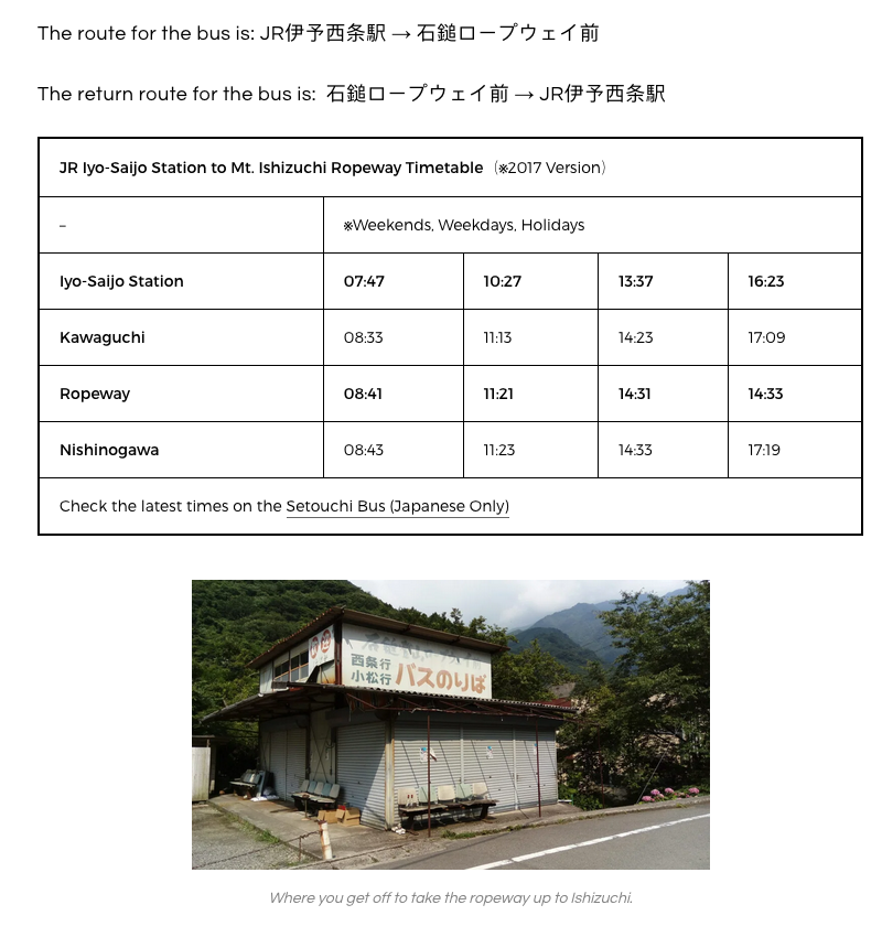
After you arrive at JR Iyo-Saijo Station, you will need to take the bus to Mount Ishizuchi. The bus costs ¥1000 one-way and you can pay in cash when you get in.
 Wait for the bus here outside JR Iyo-Saijo Station
The bus stop is right outside the JR Iyo-Saijo Station. Look for a bus that says: JR伊予西条駅 → 石鎚ロープウェイ前. There was no English when I did the trip. You take the bus to the last stop, called Nishinokawa.
 Bus stop at Ishizuchi
If you are standing at the main bus stop and have arrived before the departure time, you can be sure you do not miss your bus. Buses in the countryside may arrive late, but they will almost never depart early. If they are running early, they will usually wait until their scheduled departure time. If you are unsure, you can follow the people who look like they are going hiking. Usually, they will have gear such as walking sticks.
**From Iyo-Saijo Station to Ishizuchi’s base (Nishinokawa)
**
**JR Iyo-Saijo Station** **Nishinokawa (Last Stop)** 07:47 08:43 10:27 11:23 13:37 14:33 16:23 17:19 Source: [Setouchi Bus (Japanese Only)](http://www.setouchibus.co.jp/)
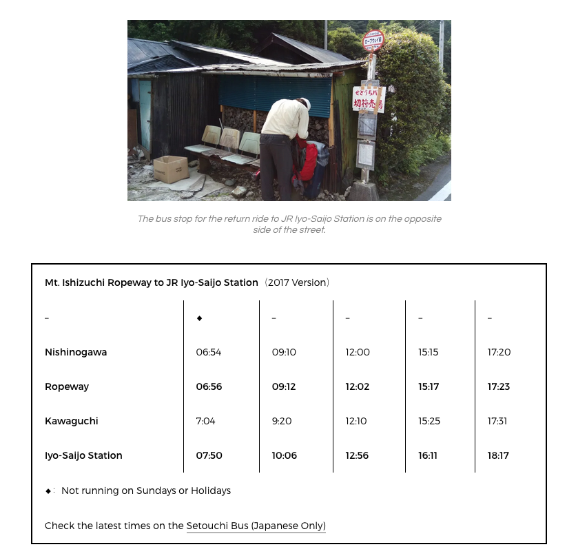
From Nishinokawa and Ishizuchi Ropeway to Iyo-Saijo Station
**Nishinokawa (First Stop)** **JR Iyo-Saijo Station** Weekdays Only 06:54 07:50 Daily 09:10 10:06 Daily 12:00 12:56 Daily 15:15 16:11 Daily 17:20 18:17 Source: [Setouchi Bus (Japanese Only)](http://www.setouchibus.co.jp/)
Hiking Route from the base of Mount Ishizuchi at Nishinokawa
The trailhead to Mount Ishizuchi should have a marker. If you need to use the toilet first, you should get off at the “Ropeway” stop before Nishinokawa and go to the toilet at the cable car station first. After that, it is about a 15 minute walk to Nishinokawa.
Please note that the description of this route covers only from the bus stop and base of the mountain. For hikers who follow Route 1, please also refer to the Omotesando route below that starts from above the cable car station. The time estimate in this section should be added to the additional time needed near the top of the mountain.
**Route 1 (Approx 3 hours to join main route): To Ishizuchi Shrine and Omotesando Route **The main route should be clearly marked and basically follows along the slopes that the cable car goes up. This route joins the “Omotesando” day hike route in the section below. This means that the 3 hours you hike up this route is in addition to the hike to the peak of Mount Ishizuchi.
Route 2: Advanced Route(s) At the first major trail fork, there will be a left route. This route is advanced and has further splits up the mountain. The various options will include joining part of the Omotesando main route, joining only in the last section with the climbing chains, or hugging Mount Omori and skipping Mount Ishizuchi altogether. That route eventually takes you down to the main Ishizuchi Shrine and the bus stop “Ishizuchi Tsuchigoya”, which is only serviced on weekends and goes to Kuma Kogen. If you take the most advanced route that still goes to Tengudake (Mount Ishizuchi’s peak), you should expect the whole route to take around 6 hours of continuous walking. You can look at this PDF map to get a sense of options from Nishinokawa bus stop.
From JR Iyo-Saijo Station to the Ishizuchi Omotesando Route (Day Hike)
 The Ishizuchi Joju Shrine where the trailhead begins.
*Omotesando hiking route from the Ishizuchi Cable Car (1400 metres) and Joju Shrine to the peak of Mount Ishizuchi (1982 metres), the tallest mountain in Western Japan, in Ehime Prefecture on Shikoku. This guide tells you how to get to Mount Ishizuchi from Matsuyama JR Station via Kuma Kogen and Iyo Saijo Station, via Yokomine-ji. This post will also give you rough estimates of route length and time expected, as most of the routes will require at least one overnight. *
From Iyo-Saijo Station to Ishizuchi
Please refer to the time tables in the section above for bus times.
The Mount Ishizuchi Cable Car
 The gift shop at the top of the cable car station has snacks.
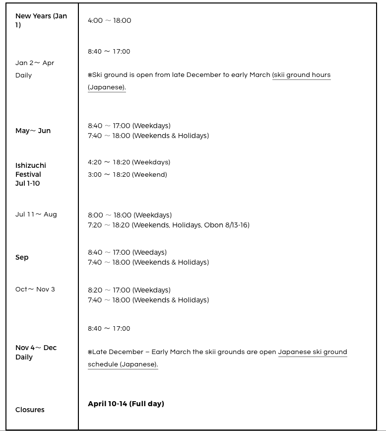
The Ishizuchi cable car car runs every 20 minutes during regular days an every 10 minutes during peak season. This means that it departs on the hour, as well as every 0:20, and 0:40.
From December until March, the Ishizuchi area has a running ski ground. For winter visitors, you can check the ski ground hours (Japanese).
Jan 2 – April 8:40 ~ 17:00
※ Dec – Mar the Ski grounds are open May & June Weekdays Sat, Sun, Holidays 8:40 ~ 17:00 7:40 ~ 18:00 Ishizuchi Festival (July 1 ~10) Weekdays Sat & Sun 4:20 ~ 18:20 3:00 ~ 18:20 July 11~ August Weekdays Sat, Sun, Holidays, Obon 8:00 ~ 18:00 7:20 ~ 18:20 September Weekdays Satu, Sun, Holidays 8:40 ~ 17:00 7:40 ~ 18:00 October ~ November 3 Weekdays Sat, Sun, Holidays 8:20 ~ 17:00 7:40 ~ 18:00 November 4 ~ December Daily 8:40 ~ 17:00 ※ Late Dec ~Early March the Ski ground hours New Year’s Day (Jan 1) 4:00 ~ 17:00 NO SERVICE April 6 – 12
The Omotesando Hiking Route from the Ropeway and Joju Shrine
Time from Joju Shrine Trail Head (One-Way): 3 hours
This is a useful 2-page English guide for the Omotesando hiking route, which includes information on accommodation.
The Omotesando route officially starts at the Ishizuchi Jōju Shrine (about 1400m), where there is a wooden gate with spirit guardians. Note that the last section has a series of 3 famous climbing chains, which are 33 metres, 65 metres and 68 metres respectively. You can refer to my climbing time log with the Strava App below:

Note on the return If you are returning on the same route via the cable car, then look for the signs that say Joju 成就. Note that the last bus leaving Mount Ishizuchi Ropeway is around 5:20pm, so you should catch the 4:40 cable car at the latest.
It is also possible to go down the mountain through other paths, such as to Tsuchigoya (look for signs where the second chain is). *Tsuchinoya *has 2 buses on weekends only that take you out to Kuma Kogen, where you can transfer to Matsuyama. Please refer to the bus time tables in the section above on transportation from Matsuyama. You can also take a longer route down to Omogo as well, which has daily buses to Kuma Kogen, but do note when the last bus departs.
From Yokomine-ji for Shikoku Pilgrimage Henro
If you are an Ohenro-san, you have probably heard of Mount Ishizuchi in the guide. I think Mount Ishizuchi is absolutely worth the climb from Spring to Fall (not winter). Note that climbing Mount Ishizuchi will definitely take one or two extra days.
This route requires no transportation, as the assumption is that you will be hiking directly from Yokomine-ji through the mountains. If you are taking the bus, please refer to the sections above on transit to and from JR Iyo-Saijo Station.
The Imamiya Route
 Just before the three chains climbing to the peak of Ishizuchi.
Time from Yokomine-ji: 5-8 hours
From Yokomine-ji, you should be following a narrow concrete car road down the mountain that eventually begins to follow the Kamo River. You will need to follow the river until you reach the bus stop called Koguchi 河口. This route takes about 2 hours.
From Koguchi, which means mouth of the river, you will begin the climb the Imamiya Route. The Imamiya Route is a mountain path and takes between 3-5 hours. You will know you are at the end of the route when you arrive at the Ishizuchi Joju Shrine and the mountain town with ryokans.
For the route information from the town please go up to the section titled “The Omotesando Hiking Route from the Ropeway and Joju Shrine” for a more detailed description. For more information on accommodation, please continue down below to the Accommodation section.
For Shikoku Pilgrims Walking the Whole Route
If you are a pilgrim who is walking the whole way, then you will probably need to retrace your step after ascending Mount Ishizuchi. The most direct route down the mountain will be to follow the Omotesando Route to the Joju Shrine and cable car station. From there, you can retrace the Imamiya Route out to Koguchi. Koguchi is the name of the bus stop that takes you out to Iyo-Saijo Station, but you will also recognise it when you see the road. If you don’t take the bus, you can continue to follow the Kamo River down the mountain, and back out to Temples #61 and #62.
For Taking Transit back to Temples #61 or #64
If you are open to taking the bus back out of the mountains to resume your walk, please refer to the section above on cable car and bus times to JR Iyo-Saijo. If you walked directly from Yokomine-ji, Temple #60, you will have to take the train back to Temple #61 to continue walking.
If you are more flexible with your route, then a better way would be to walk Temples #61 – #64 first as they are close together. Then do Yokomine-ji (Temple #60), and hike up to Mount Ishizuchi from there. As you have already walked to the other temples, you can continue walking immediately towards Temple #65 after the bus drops you off at JR Iyo-Saijo.
Additional Information
Accommodations Around Ishizuchi
 There is a mountain lodge beside this office at the peak.
You can refer to the ryokans listed on this map and also look for rest huts along the trail.
Climbing Etiquette in Japan
Japan is a safe place to climb mountains and many routes are cared for by local communities. For this reason, this is a gentle reminder to go by the principle of taking everything off the mountain with you, so that you leave it in the same beautiful state you found it. Below are a few additional cultural notes to help you on your hike on Ishizuchi, as well as other mountains on Shikoku.
 *Use the spray to flush the toilet, which is on Mount Ishizuchi and other mountains.
*
*Use the spray to flush the toilet, which is on Mount Ishizuchi and other mountains.
*
- Keep your garbage and take it down the mountain
- Say ‘konichiwa’ as a friendly ‘hello’, which the hiking community frequently does
- Say ‘sumimasen‘, which means ‘excuse me’ to pass people, or step in to use something (such as a water fountain)
- Keep conversation voices low as noise travels far
- Follow instructions in washrooms because the waste gets flushed right onto the mountain
Mount Ishizuchi Ropeway and Lodgings
*If this section is weirldy formatted, try the version I’ve saved in the internet web archive here.
The route I took was:
The closest major cities to Mount Ishizuchi are Takamatsu (Kagawa Prefecture) and Matsuyama (Ehime Prefecture). Many people who drive across the Shimanami Kaido will also stop at Imabari, which is a small city that’s a few stops from the closest train station.
This guide is only for people taking public transit, which includes trains, a local bus, and a ropeway up the mountain. I’m not familiar with driving routes!
Getting in:
- Use Google Maps to search your train route to Japan Rail (JR) Iyo-Saijō Station. Google maps in Japan is very reliable and has exact train times.
- Take a bus from outside Iyo-Saijo Station to Ishizuchiyama (JR伊予西条駅 → 石鎚ロープウェイ前). Note: 4 daily buses only.
- Get off at Ishizuchiyama (石鎚山) stop.
- Walk up a hill to take the ropeway.
- Take the Ishizuchi Tōzan Ropeway (石鎚登山ロープウェイ) up the mountain. (¥1000 adult one-way, ¥1950 round trip)
Getting out:
- Take the Ishizuchi Tōzan Ropeway (石鎚登山ロープウェイ) back down the mountain.
- Take the bus back to Iyo Saijo Station.
- Take the train from Iyo-Saijo Station back to where you are staying.
Trains
You must note the exact trains that match the 4 scheduled bus times.
For example, to meet the 10:27 morning bus from Iyo-Saijo Station you would have to take:
- From Takamatsu: Ishizuchi #7, departing at 8:44
- From Okayama: Shiokaze #3, departing 8:30
- From Matsuyama: Shiokaze #12 departing at 9:12
I took an early train from Imabari to catch the 7:47 bus from Iyo-Saijo.
You can look up the train prices on Hyperdia, but if you have a JR Pass or All-Shikoku Pass it doesn’t matter.
Buses
Buses in Japan are pretty punctual. Surprisingly, mine at 7:47 was not that day. The tip is, definitely be on time because buses will leave on time, but don’t panic if it’s not on the dot! The bus stop has several different bus routes, so make sure you look at the bus sign before getting on. Don’t just get on any bus that arrives at 7:47. The bus you’re looking for has the route name blow
The route for the bus is: JR伊予西条駅 → 石鎚ロープウェイ前
The return route for the bus is: 石鎚ロープウェイ前 → JR伊予西条駅
Ishizuchi Tōzan Ropeway Times
Translation of the Japanese Ropeway Timetable.
Departures are every 20 minutes, so at 0:00, 0:20, and 0:40.
Price: ¥1950 Adults, ¥980 Children
I went in the summer and the ropeway opens at 9:00am. This means that if you take the 7:47am bus, you will probably have a little bit of extra time.
Mount Ishizuchi Climbing Route
Mount Ishizuchi is famous for three sets of iron chains that climbers traditionally used to get to the peak. These days, a walking route is also available. I would recommend printing the English map for climbing Mount Ishizuchi as I found the information and route estimations quite accurate and helpful. Download the PDF here.
The most popular route, from the Ishizuchi Ropeway (cable car) is also the shortest. The recommended time for the route is 3 hours up, and 3 hours down, which probably factors in plenty of time to enjoy the scenery. I did the route in 2:26 going up (moving time 1:53) and 1:29 going down.
Lodgings
Note that most places on Shikoku only speak Japanese, and a phone reservation prior is recommended. If you walk in, you will want to ask if there is room that day by noon, although the room may not be prepared until after 3pm. Most places come with a dinner prepared, and maybe a breakfast as well. The prices differ based on how many meals you want.
Below is a list of lodgings at Mount Ishizuchi. There is one lodge at the peak, and a cluster of places to stay at the top of the ropeway.
Shimotani (Base of the Ropeway)
Onsen Ryokan Kyoya (京屋旅館) ☎ 0897-59-0335 106 Nishinokawako, Saijo, Ehime Prefecture 793-0215, Japan
To be honest, from the outside, it doens’t look the greatest. Assuming the price is around the same as the ryokans at the top of the ropeway, I would suggest staying in one of those instead. Of course, if you want an onsen, then this is the one to stay at after a long day.
In Ishizuchi Komatsucho
*30 mins walk after the top of the Ishizuchi Ropeway, where the Ishizuchi Chugu Jojusha Shrine and entrance to the Ishizuchi trail is。
Hinodeya Ryokan (日の出山旅館) ☎ 0897-59-0143
Tamaya Ryokan (玉屋旅館) ☎ 0897-59-0415
Shiraishi Ryokan (白石旅館) ☎ 0897-59-0032
The three ryokan are the only buildings on the mountain that you will definitely pass when walking from the ropeway station to the Mount Ishizuchi trail. Together with the Joju Shrine.
At Mount Ishizuchi Peak
Chōjō-sansō (頂上山荘), ☎ 0897-55-4168, The name actually means summit lodge description of this mountain hut run by the temple. It’s open from early May to early November. The lodging is pretty basic, but still costs ¥8500 with two meals, so budget yourself before deciding to just show up!
Useful Vocabulary (especially for map reading)
Note that all vowels are pronounced in consistently in Japanese. This means:
- a = short a (as in ‘bat, at’)
- i = ee (as in ‘tree’)
- u = oo (as in ‘too’)
- e = short e (as in ‘get’)
- o = long o (as in ‘role, sole, coal’)
- ai = long i (as in ‘I‘)
- ei = long a (as in ‘Say’)
- yu = long u (as in ‘shoe’)
- oe = long o + short e (oh + eh?), two sounds
Map:
- Peak – (Sanchō) 山頂
- Information – annai (案内)
- Bus – basu (バス)
- Bus stop – basu tei (バス停)
- Station – eki (駅)
- Toilet _– toire (_トイレ) or tearai (手洗い )
Places
- Iyo-Saijo JR Station – Iyo Saijo Eki (伊予西条駅)
- Ishizuchi Cable Car – _Ishizuchi ropuwei mae (_石鎚ロープウェイ前)
- Mount Tengu Peak – Tengudake 天狗岳
Accommodation / Bookings
- Inns – ryokan (旅館), _Minshuku (_民宿) , _Shukubo (_宿坊)
- Reservation – yoyaku onegai shimasu (予約お願いします)
- Stay 1 night – ippaku (一泊)
- Stay 2 nights – nipakku (2泊)
- One person – hitoride (一人で)
- Two / three / four people – ninin / sannin / yonin (2人、3人、4人)
- Meals – shokuji (食事)
- Stay without meals – sudomari (素泊まり) otherwise usually at least one meal is assumed.